Observation details

Overview

Estuary Anglesea River Estuary
Site Fishing platform upstream of Great Ocean Rd Bridge
Observation ID #12931
Date and Time Wednesday 19th December 2018 09:15am
Approved Approved

Notes

ISC Site. Mouth Closed.

Depth Profiling

Depth m Temperature °C Salinity ppt D.O. mg/L D.O. % sat EC mS/cm Notes
0.1m 22.10 11.60 6.40 78.5 19.57
Previous 22.0 10.9 6.1 73.9 18.3
Median 17.1 9.00 8.72 94.00 15.3
0.3m 22.20 11.70 6.40 78.5 19.62
Previous 20.7 11.3 6.5 75.6 19.0
Median 17.1 9.00 8.72 94.00 15.3

Top-Bottom Sampling

Depth m Turbidity NTU pH
Top 0.1 2 7.5
Previous 0.1 9 7.5
Median 0.1 9 6.1
Bottom 0.3 3 7.1
Previous 0.3 9 7.4
Median 0.5 9 5.8

Other details

Max depth 0.45
Previous 0.45
Median 0.60
Flow estimate N/A

Observation Documents

Link Date File name Description

Download
13-05-2019 14:00 IMG20190513105535.jpg

Preceding Observations

C Estuary is closed to the sea. O Estuary is open to the sea. P Perched
Creative Commons CC BY
All content, files, data and images provided by the 
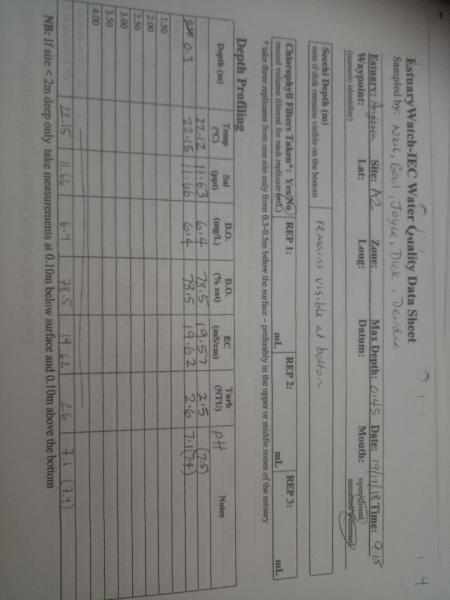
EstuaryWatch Data Portal and Gallery are subject to a Creative Commons Attribution License

Content is made available to be used in any way, and should always attribute EstuaryWatch and www.estuarywatch.org.au