EstuaryWatch Data Portal
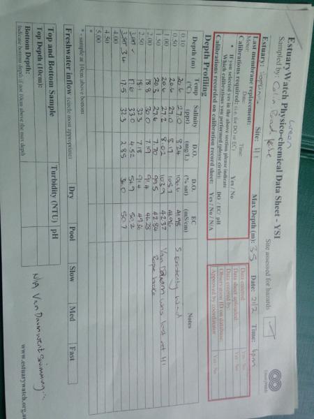
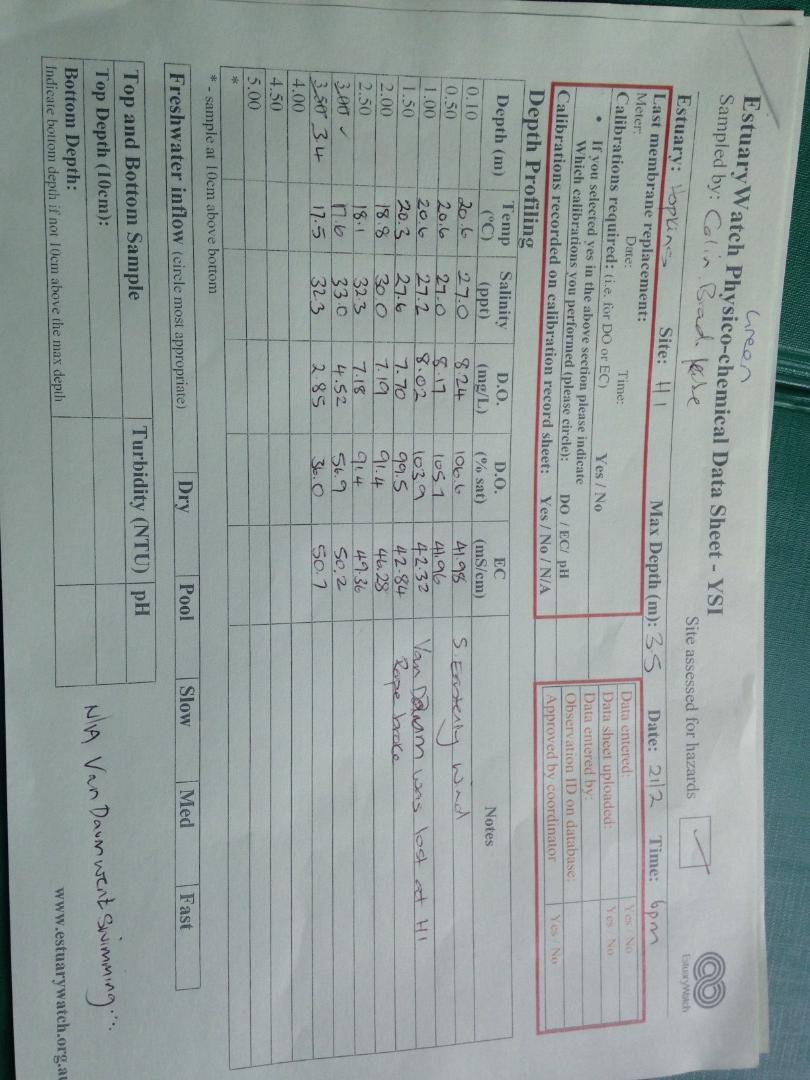
H1 Site one (Hopkins River Bridge)
21 February 2020
Observation details
Overview
| Estuary | Hopkins River Estuary |
|---|---|
| Site | Site one (Hopkins River Bridge) |
| Observation ID | #13596 |
| Date and Time | Friday 21st February 2020 18:00pm |
| Approved | Approved |
Depth Profiling
| Depth m | Temperature °C | Salinity ppt | D.O. mg/L | D.O. % sat | EC mS/cm | Notes | |
|---|---|---|---|---|---|---|---|
| 0.1m | 20.60 | 27.00 | 8.24 | 106.6 | 41.98 | ||
| Previous | 19.2 | 28.0 | 9.6 | 122.7 | 43.4 | ||
| Median | 15.9 | 8.10 | 9.40 | 100.60 | 14.0 | ||
| 0.5m | 20.60 | 27.00 | 8.17 | 105.7 | 41.96 | ||
| Previous | 25.2 | 21.9 | 9.1 | 126.9 | 34.8 | ||
| Median | 15.9 | 8.10 | 9.40 | 100.60 | 14.0 | ||
| 1.0m | 20.60 | 27.20 | 8.02 | 103.9 | 42.32 | ||
| Previous | 18.8 | 28.6 | 9.1 | 116.2 | 44.3 | ||
| Median | 14.7 | 11.20 | 9.07 | 95.60 | 19.0 | ||
| 1.5m | 20.30 | 27.60 | 7.70 | 99.5 | 42.84 | ||
| Previous | 19.4 | 30.5 | 6.5 | 84.5 | 46.9 | ||
| Median | 14.7 | 11.20 | 9.07 | 95.60 | 19.0 | ||
| 2.0m | 18.80 | 30.00 | 7.19 | 91.4 | 46.28 | ||
| Previous | 16.9 | 33.2 | 6.7 | 83.7 | 50.5 | ||
| Median | 14.3 | 22.60 | 8.32 | 94.40 | 35.7 | ||
| 2.5m | 18.10 | 32.30 | 7.18 | 91.4 | 49.36 | ||
| Previous | 18.4 | 32.0 | 6.3 | 82.3 | 48.9 | ||
| Median | 14.3 | 22.60 | 8.38 | 95.60 | 35.7 | ||
| 3.0m | 17.60 | 33.00 | 4.52 | 56.9 | 50.20 | ||
| Previous | 16.7 | 33.3 | 6.0 | 75.3 | 50.6 | ||
| Median | 14.3 | 29.30 | 6.62 | 75.30 | 45.3 | ||
| 3.4m | 17.50 | 32.30 | 2.85 | 36.0 | 50.70 | ||
| Previous | 18.2 | 32.3 | 5.1 | 66.0 | 49.4 | ||
| Median | 14.3 | 29.30 | 7.10 | 79.40 | 45.3 |

All content, files, data and images provided by the EstuaryWatch Data Portal and Gallery are subject to a Creative Commons Attribution License
Content is made available to be used in any way, and should always attribute EstuaryWatch and www.estuarywatch.org.au