EstuaryWatch Data Portal
P2 Great Ocean Road Bridge at Aireys Inlet
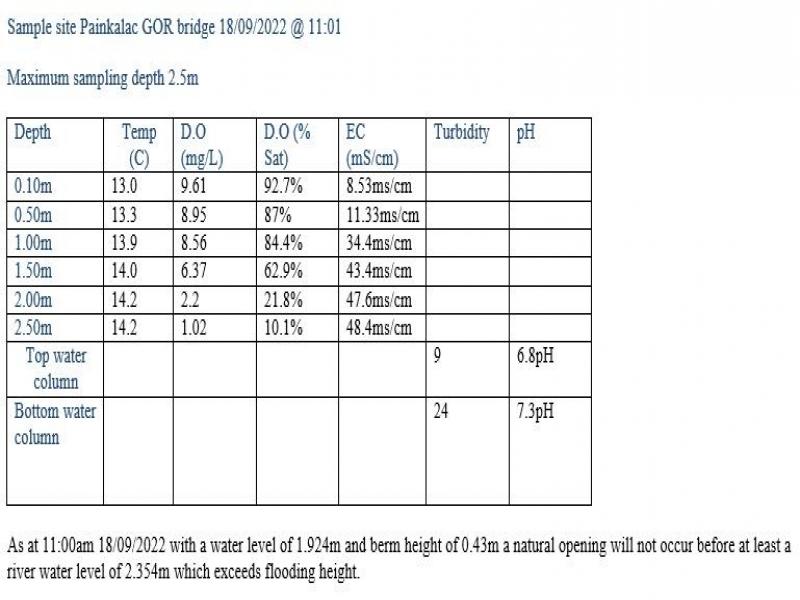
18 September 2022
Observation details
Overview
| Estuary | Painkalac Creek Estuary |
|---|---|
| Site | Great Ocean Road Bridge at Aireys Inlet |
| Observation ID | #15041 |
| Date and Time | Sunday 18th September 2022 11:00am |
| Approved | Approved |
Depth Profiling
| Depth m | Temperature °C | Salinity ppt | D.O. mg/L | D.O. % sat | EC mS/cm | Notes | |
|---|---|---|---|---|---|---|---|
| 0.1m | 13.00 | 6.30 | 9.61 | 92.7 | 8.53 | ||
| Previous | 14.0 | 38.8 | 3.1 | 30.4 | 46.0 | ||
| Median | 14.4 | 26.30 | 9.18 | 90.70 | 37.7 | ||
| 0.5m | 13.30 | 8.50 | 8.95 | 87.0 | 11.33 | ||
| Previous | 11.9 | 25.6 | 9.5 | 88.7 | 30.1 | ||
| Median | 14.4 | 25.60 | 9.18 | 90.70 | 36.4 | ||
| 1.0m | 13.90 | 28.20 | 8.56 | 84.4 | 34.40 | ||
| Previous | 14.0 | 41.5 | 1.2 | 11.9 | 48.8 | ||
| Median | 16.8 | 35.50 | 7.86 | 90.40 | 48.8 | ||
| 1.5m | 14.00 | 36.40 | 6.37 | 62.9 | 43.40 | ||
| Previous | 13.8 | 37.0 | 6.9 | 67.6 | 52.9 | ||
| Median | 16.8 | 33.90 | 7.86 | 90.40 | 48.3 | ||
| 2.0m | 14.20 | 40.10 | 2.20 | 21.8 | 47.60 | ||
| Previous | 14.0 | 38.8 | 3.5 | 34.7 | 46.0 | ||
| Median | 17.7 | 35.90 | 5.13 | 59.10 | 46.0 | ||
| 2.5m | 14.20 | 40.90 | 1.02 | 10.1 | 48.40 | ||
| Previous | 14.1 | 37.2 | 7.6 | 74.7 | 53.1 | ||
| Median | 17.7 | 34.60 | 5.13 | 59.10 | 44.1 |


All content, files, data and images provided by the EstuaryWatch Data Portal and Gallery are subject to a Creative Commons Attribution License
Content is made available to be used in any way, and should always attribute EstuaryWatch and www.estuarywatch.org.au