EstuaryWatch Data Portal
GMC Gellibrand River Estuary Mouth Observation Site
3 February 2013
Observation details
Overview
| Estuary | Gellibrand River Estuary |
|---|---|
| Site | Gellibrand River Estuary Mouth Observation Site |
| Observation ID | #8049 |
| Date and Time | Sunday 3rd February 2013 10:10am |
| Approved | Approved |
Notes
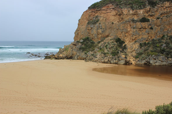
1.Mouth barred
2.Estuary has moved closer to top of berm
3.Beach is now wide with gradual slope, sand cliffs are almost removed by wave action
4.AHD same at G6 & G2 1.38
5.Lots of small fish in flood water near AHD board G2
6.Water just starting to form on side of top track & near flood marker on OOR (below 0.2) road crown above water
7 Water increasing on flats between Princetown G4 & Rivernook (extends further up south side of channel to G5
Mouth Observation
| Mouth state | Closed |
|---|---|
| Previous | O C O O O O O P P P C O P O O O P O O O O O O O O O O O O O O O O O O O O O O O O O O O O O O C C C C C |
| Flow Present? | No |
| Previous | Y N Y Y Y Y Y Y N N N Y N Y Y Y Y Y Y Y Y Y Y Y Y Y Y Y Y Y Y Y Y Y Y Y Y Y Y Y Y Y Y Y Y Y Y N N N N N |
| Flow Direction | N/A |
| Previous | O N O O O O O I N N N I N I I O I O O O O O O O O O O O O O O O O O O O O O O O O O O O O O O N N N N N |
| Above Sea | Above Estuary | |
|---|---|---|
| Berm Height (m) | 0.7m | 0.4m |
| Berm Length (m) |
Physical Condition
| Current | Mode | |
|---|---|---|
| Wind Direction | South-West | |
| Beaufort Scale | Light Breeze | |
| Sea State | Moderate |


All content, files, data and images provided by the EstuaryWatch Data Portal and Gallery are subject to a Creative Commons Attribution License
Content is made available to be used in any way, and should always attribute EstuaryWatch and www.estuarywatch.org.au