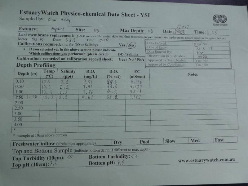
EstuaryWatch Data Portal
H3 Site three (Mahoneys Road)
19 August 2017
Observation details
Overview
| Estuary | Hopkins River Estuary |
|---|---|
| Site | Site three (Mahoneys Road) |
| Observation ID | #11402 |
| Date and Time | Saturday 19th August 2017 11:05am |
| Approved | Approved |
Depth Profiling
| Depth m | Temperature °C | Salinity ppt | D.O. mg/L | D.O. % sat | EC mS/cm | Notes | |
|---|---|---|---|---|---|---|---|
| 0.1m | 10.30 | 2.20 | 9.91 | 89.6 | 4.14 | ||
| Previous | 10.7 | 8.5 | 11.5 | 108.8 | 14.6 | ||
| Median | 18.6 | 11.00 | 8.86 | 108.80 | 18.1 | ||
| 0.5m | 10.30 | 2.20 | 9.93 | 89.8 | 4.14 | ||
| Previous | 11.5 | 10.4 | 12.4 | 121.0 | 17.7 | ||
| Median | 18.7 | 21.00 | 8.86 | 110.30 | 30.1 | ||
| 1.0m | 10.30 | 2.20 | 9.86 | 89.2 | 4.14 | ||
| Previous | 13.2 | 21.4 | 6.8 | 75.7 | 33.9 | ||
| Median | 13.8 | 20.30 | 6.22 | 66.40 | 31.7 | ||
| 1.4m | 10.30 | 2.20 | 9.67 | 88.2 | 4.15 | ||
| Previous | 13.8 | 20.3 | 5.5 | 61.4 | 31.7 | ||
| Median | 14.6 | 20.30 | 6.22 | 66.40 | 31.7 |

All content, files, data and images provided by the EstuaryWatch Data Portal and Gallery are subject to a Creative Commons Attribution License
Content is made available to be used in any way, and should always attribute EstuaryWatch and www.estuarywatch.org.au